East Mathers, West Mathers and Milton of Mathers are villages just north of St Cyrus and the Kaim of Mathers (see previous post https://mountainsrivers.com/2014/05/11/a-visit-to-the-mathers-ancestral-castle-in-scotland/). St Cyrus is about 60 km north east of Dundee in Angus and about 50 km south of Aberdeen. St Cyrus lies between the mouths of the South and North Esk Rivers, and developed at a natural harbour that traded in skins, hides and cured salmon in medieval times. It is about 50 km south of Aberdeen. The cliffs and dunes provide a nationally important habitat for flowering plants and insects, and a breeding ground for tern and have been declared a National Nature Reserve.
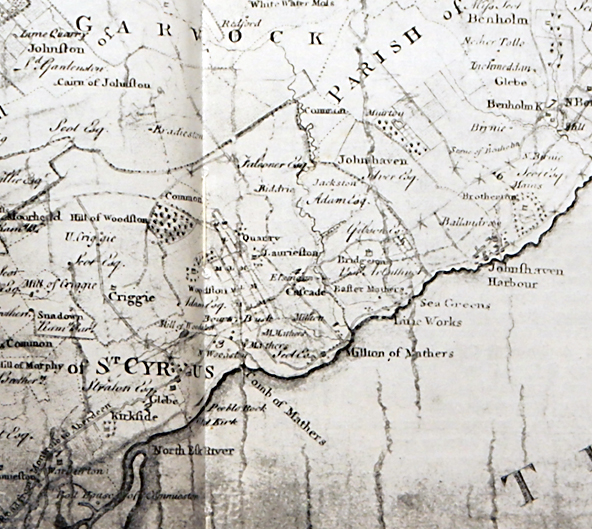
While there is real evidence that the Mathers of Scottish ancestry originally came from the Mathers villages, I find it nice to imagine that they did. As I was in Scotland for meetings after Easter, I took a few extra days and visited the Kaim of Mathers and the Mathers villages. I stayed in the Old Fishing Station in the St Cyrus Nature Reserve and found a history of the district in my room, a book first published in 1970 by Duncan Fraser (Duncan Fraser. St Cyrus: Portait of a Parish. Montrose: Standard Press; 1979). Much of the information below is paraphrased from this book, which I thoroughly enjoyed reading while I was there. Below is a copy of a survey map from 1774 showing the villages of East Mathers, West Mathers, Milton of Mathers and Miltonhaven.
Looking at the fertile farmlands around Mathers today, its hard to realize how little of it was under cultivation as little as two and a half centuries ago. The land consisted mostly of marsh and stony wasteland and what little was under cultivation was unfenced. The only crop grown were oats and bear, an early form of barley, and the higher food value crops of today were unknown. Until about 1750, every farm consisted of an infield where the crops were grown and which were plowed using oxen, and an outfield about four times as large that was given over to the livestock, mainly sheep and cows. Humans and animals co-habitated up until the early eighteen hundreds. Farming was largely subsistence farming and little surplus was produced for sale or barter. Food consisted of oats, ground by a local miller, and used as porridge or oatmeal biscuits and in the evenings washed down with a local whisky. Meat and fish were a luxury to the average person, and these were usually only consumed at local fairs.

In the 50 years after 1750, farming underwent a revolution in Scotland. A small number of Scottish innovators introduced methods developed in England and experimented to find ways to increase agricultural yield. This included use of lime as fertilizer and in 1750, Robert Scott, member of parliament for a neighbouring county, opened a lime quarry at Miltonhaven and limekiln at Milton of Mathers. He also introduced potatoes, turnips and clover. Turnips allowed farmers to feed cattle through winter, whereas formerly they had to kill and salt most of them at the beginning of winter.
In addition to farming and weaving, salmon fishing was a major activity for the area in the eighteenth century when fish were packed and salted in barrels and exported from Montrose to the Baltic, the Netherlands, and the Mediterranean. Local salt, from the tidal saltings at St. Cyrus, could not be used and it had, by regulation, to be Portuguese salt. Salting later gave way to packing in ice and this meant salmon could be transported to, for example, London, and still arrive as fresh fish.

Miltonhaven was the largest of the villages in the district, down on the edge of the sea just beyond Milton of Mathers. In the 1700s, it was the largest and the busiest of the hamlets in the district. Every week it had a market day and twice a year, in May and October, the crowds came flocking from all over the Mearns to its four-day fair. In the first half of the 1700s, the mainstays of Miltonhaven were fishing and smuggling. The town of Montrose about 6 miles south was Scotland’s chief tobacco port, and as the big tobacco ships from America came down the coast it was only too easy to push some of the cargo overboard and let them drift ashore. This was not just a few packages going over the side, one night in 1742, three tons were seized by the Customs men at Miltonhaven.
But everything changed when Scott built his kiln at Milton of Mathers in 1750 and began the blasting of the natural limestone breakwater which protected the village from the sea. The population doubled in the next few years, and the red glow of the kiln was like a welcoming beacon for every ship that carried contraband. Soon the limerworkers took up smuggling, and they were a tougher bunch than the fishermen. After one incident in 1760 in which two Customs men were surrounded by a crowd of locals and panicked and shot one of them, it became too dangerous for the Customs men to move around unless they had soldiers with them, and at night too dangerous even with the soldiers. The coast was clear and smuggling brought a new wave of prosperity to Miltonhaven and the Mathers villages. Along with gin and brandy from the Low Countries, the locals became used to tea from China and sugar from the West Indies. But the good times did not last.
The village was built on an ancient shingle beach, protected from storms by a natural limestone breakwater, and it was this breakwater that Scott mined for lime. In the 1790s, there was a fierce storm, and according to the only contemporary account, the waves broke through and completely washed away the village in one night, leaving the shore 150 m further inland than before.
This may not be quite true. Thirty years later, the St Cyrus schoolmaster collected eyewitness accounts and was told quite emphatically that only part of the village had been swept away in 1792. A massive wall was built around the rest of the village to protect it, and the quarrying continued. But this strategy was not successful, and the lime workings and most of the remaining cottages soon disappeared like the others under the sea.
The Milton of Mathers limeworks were abandoned and the lime works moved a half-mile further north to East Mathers where a new kiln was built and there were two layers of limestone eight to fourteen feet thick. These layers dipped steeply and after the surface had been mined, the mining had to go deeper and deeper underground, and flooding became a major problem. All day long a couple of horse kept a pump working to control the rising water. By 1807, a steam engine had replaced the horses, and the mine had reached a depth of more than one hundred feet to follow a seam only eight feet thick. For almost twenty years, the mine was successful selling around 40,000 barrels of lime each year to the farmers of the district. But competition from cheaper English lime eventually led to the closing of the East Mathers limeworks in 1836.
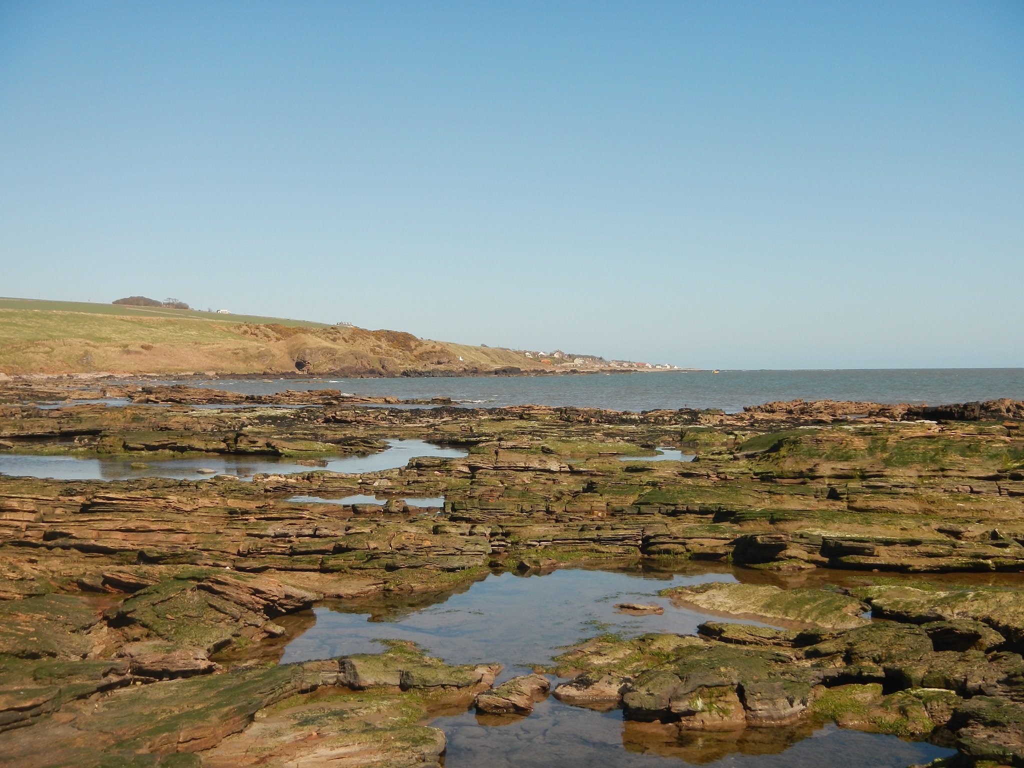
Shoreline at East Mathers
There were upwards of 50 houses and 170 inhabitants in Miltonhaven just before it disappeared and the population was still then growing. A little further south, just past West Mathers, another village called Tangleha was built on the coast to replace it. But Tangleha never compared even remotely in size with Miltonhaven, and St Cyrus became the biggest village in the parish.

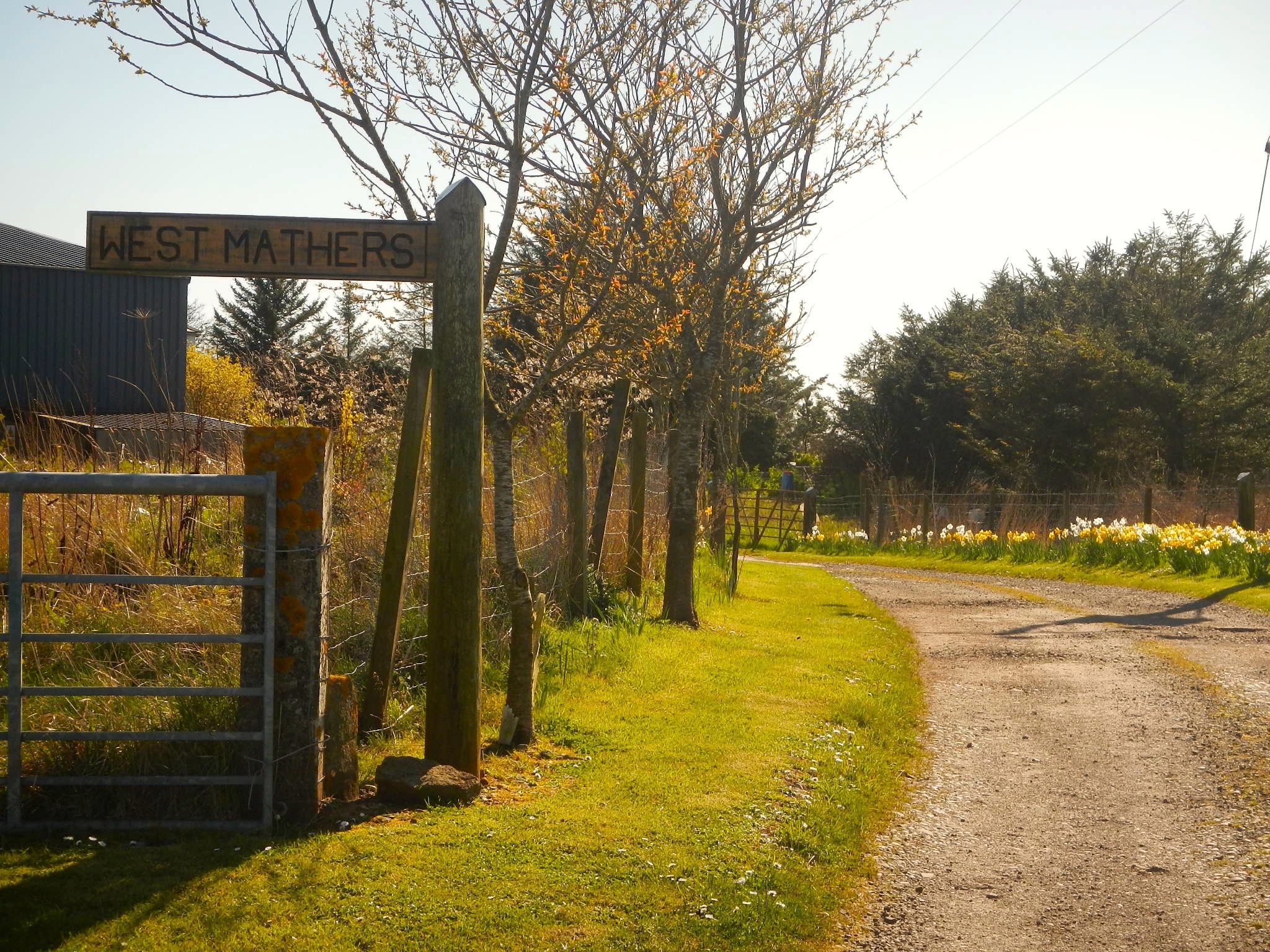 When I visited West Mathers, it was no more than a sign post and a few farms. At the end of the road past West Mathers were a small cluster of cottages behind the beach, and one of these called itself Tangleha, the last trace of the previous village. The West Mathers farm had a quite striking white farmhouse on the headland north of the Kaim of Mathers.

The Kaim of Mathers and the village of West Mathers (on the headland beyond)
My original post identified a waterfall just to the south of the Kaim as the Den o’ Finella. But I had mistaken the location of the Den, which is a little further north and harder to get to — perhaps the next time I am in the region I’ll take a look. The Den of Finella is named after Finella, wife of the Maermor (Sheriff) of the Mearns, who threw herself to her death there to escape the wrath of the King’s men, having contrived the death of King Kenneth III of Scotland in the year 995 CE, in veangence for the execution of her son. The Mearns was the Gaelic name for Kincardineshire (from A’ Mhaoirne meaning ‘The Stewartry’).On the 1774 map above, the gorge in the photo below is identified as the Comb of Mathers.
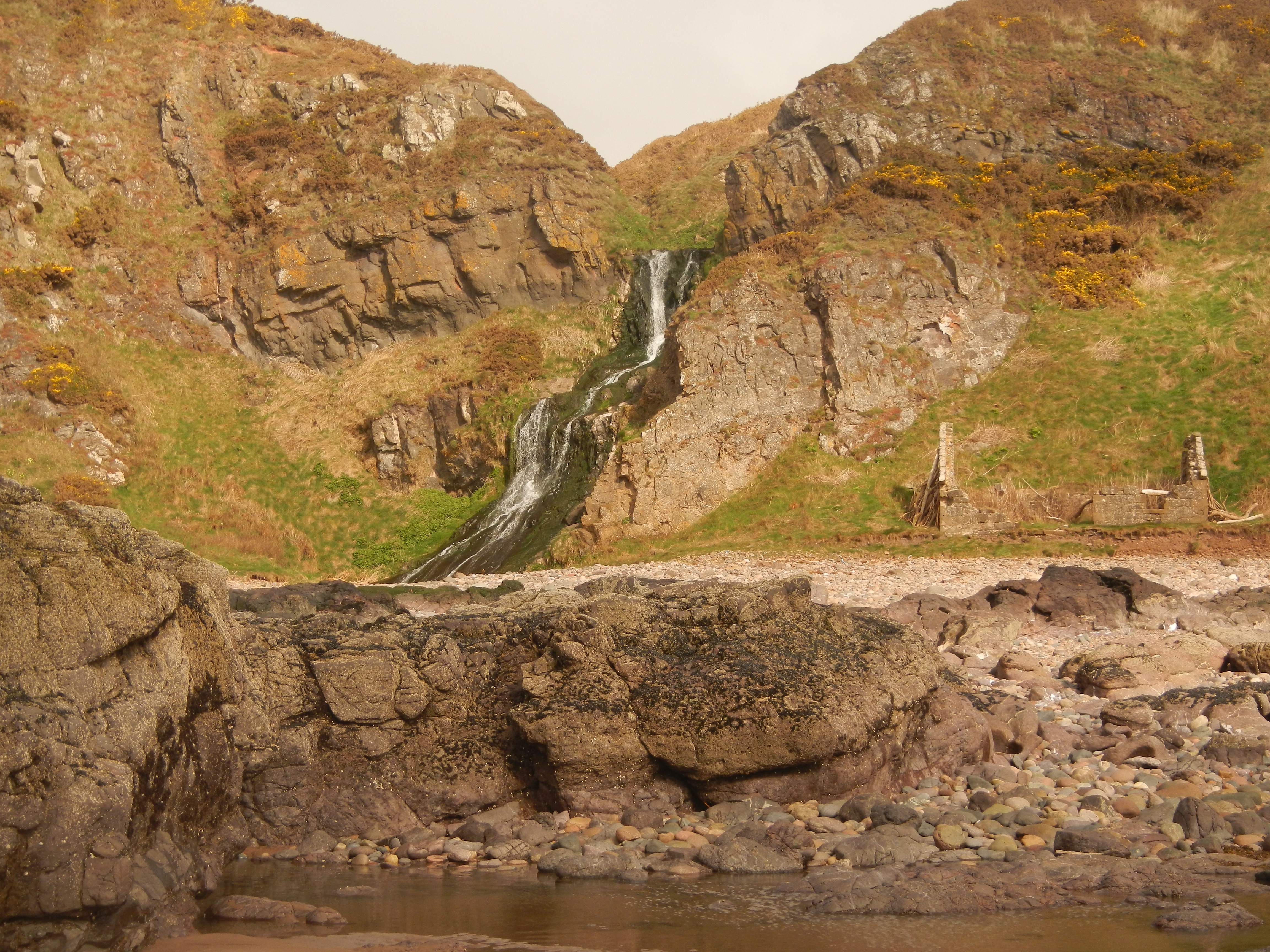
The Comb of Mathers

Pingback: Nine Stanes, Eslie the Greater and Eslie the Lessor | Mountains and rivers
brilliant,graham james mather from dundee just doon thi road
Surely the wrong photograph for the waterfall, that is the waterfall from St. Cyrus beach!
You may be right. I’ll have to check my photos and see if I can figure out where this one was taken.
As i said before the photo is of the waterfall at St. Cyrus beach! I had actually just been there two weekends ago!
I have been hunting for the waterfall that you called Den of Finella, i finally found the place in which it is located but i didnt go down to it due to adverse weather conditions! Therefore i have still to see it! When i was doing research, i came across your information of the area of Mathers. The waterfall lies between East Mathers and Milton of Mathers Grid Ref:77227 66490.
Hopefully i’ll get to it soon!
Regards Lorna
Thanks Lorna. I took a look at the map, and indeed I had misidentified the waterfall at St Cyrus. I found a couple of videos of the Den of Finella, and I had not been there. So one day I will have to get back to the area and find it. Now I have a quite accurate location, I should not go wrong. When I have a moment, I will edit the post to fix this.
Fascinating stuff… I’m descended from Alexander de Berkley so this is a great read… I love the scenery… I’m hoping to get up to see what’s left of the family castle before it disappears into the sea… 😊😊